People never mention the earthquake nor the tsunami directly here; instead they talk about the shinsai, or "the disaster." You hear this word a lot, and many conversations are either "before the disaster" or "after the disaster."

This is one to two apartment buildings destroyed by the tsunami. The other building was torn down, but you can see how the wave destroyed four stories but didn't reach the fifth floor. We've heard people talk about wave heights from ten to sixteen meters.

A massive earthen wall is slowly being built, approaching the apartment building.

This was the former tourist information center, located near the former shoreline. There is now a very small building at this site with information about the disaster and two memorial stones.

The interior of the information center.

A photo showing the complete destruction of Rikuzentakata, which sat on the broad, low delta of the Kesen River. The dark rectangles in the center are former rice fields, but this was the city center.


The former youth hostel, which was situated on a beautiful pine-covered spit of land. I remember going for a run in this seaside pine forest my first trip here in the 1990s. The forest was swept away and the spit itself is now gone.

70,000 pine trees stood on this famous spit and after the tsunami just one was left standing. Dubbed the "Miracle Pine" it became a symbol for the region. Unfortunately it later died and we believe the top was cut off and a replica of its upper branches was added to the dying trunk. The public is allowed to walk out through the reconstruction zone to get a close look at it.

Near where the spit defined the shoreline now a huge earthen and concrete seawall is being built.

This is part of a colossal conveyor system carrying earth from a mountain across the river, creating a plateau where the city stood. The idea is to rebuild on this new, artificial table land.

I suppose this technology comes from the mining industry, but I can't imagine it existing anywhere else on the scale seen here.

The mountain across the river that is being eaten away to rebuild Rikuzentakata.


The conveyor system branches and stretches in all directions.

The final leg of each conveyor is on a wheeled carriage, and can pivot on a semicircular railroad track beneath it to spread the earth.

"The Bridge of Hope" as its called, the conveyor crossing the river.


The local train ran along the coastal lowlands and it will be rebuilt inland, on higher ground. They paved a one lane road over the rail bed and run buses.

All along the coast various construction projects are enlarging seawalls and setting blocks along the shoreline.

This massive harbor reconstruction seems to be for one fishing boat.

Temporary housing like these tiny units are all over the region. Four years after the disaster and only a small percentage of victims have been able to move into permanent housing.

This building is close to where we are staying. Located in the port, it was swept clean down to the framing by the tsunami. Our inn is a replacement built on a raised earthen bed on the site of the former inn.

The coastal lowlands are full of empty house foundations.

Our local seawall is basically being doubled in height...

... and extended.

Mr. Murakami's house and shop, with the boat visible. You can just make out the cove down below. He said the tsunami came in three waves over a thirty minute period and the water rose to just the edge of his home. I've tried to figure how high the water had to have risen to reach his home but it must be fifty or sixty feet.

A series of descending rice paddies across the street from the Murakamis. They said these were full of boats from the cove, and the seawater poisoned the soil. The hope is this crop of rice, four years after the tsunami, will finally be all right.

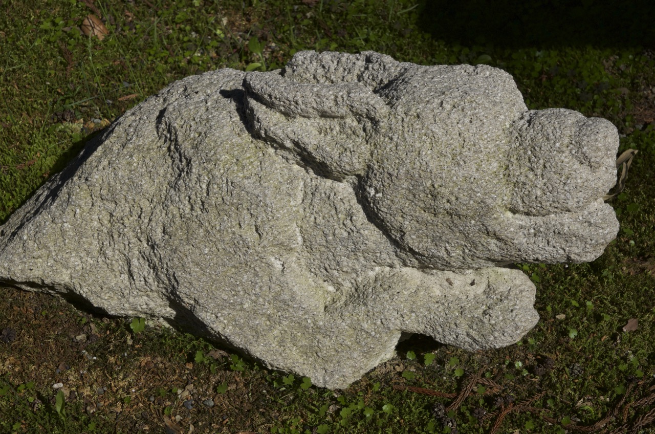
Rikuzentakata's major Buddhist temple invited people to carve stones in a large memorial. There are many figures, both wistful and sobering.

On a point below the Murakami's house is a stone marking the grave of 35 people killed in a tsunami in the 1890's. Mrs. Murakami said the local people gathered the bodies from the shoreline and buried them at this spot in a mass grave. Major tsunamis have struck this coast in the 1890's, 1933, 1960, and 2011.

As a visitor, its really impossible to reconcile the scale of what happened with the incredible beauty of this place. We have both been struck by the friendliness of everyone we've met, but beneath there is also mass trauma here. Everyone has a story. Everyone knows people who were killed. I've read many accounts that the government is reluctant to spend reconstruction funds on an area deemed rural and backward, but the region seems anything but that to me. There seem to be lots of school age children (conspicuously absent in many other rural parts of Japan), there are almost no empty houses, and the fishing industry seems thriving.

Thanks for these photos, and for posting
ReplyDelete